The Grumpy Retiree’s Hiking Journal of Acadia National Park Maine
This is The Grumpy Retiree’s Guide Hiking Journal of Acadia National Park (Acadia). I have been vacationing in and around Acadia for over 40 years and now spend 6 months here from May to October. I am only 50% as grumpy when I am here, and for those mathematically challenged that’s approximately half as grumpy.
This page will be updated as I add hikes. Check back often, or don’t. Either way I don’t care. If I stop updating this page it is either because I hiked every trail or fell off a mountain.


Table of Contents:
Grump Tip: Buy a Park Pass! You need one for the Park Loop Road and all parking in Acadia. Save time and buy online HERE. Are you 62 or older? Get your Old Person Pass HERE. The Lifetime Senior Pass (Old Person Pass) is a fantastic deal and you should have one! I am so old I have 4! Be advised, from around Mid-May until about November 1st to drive up (wimp) to the top of Cadillac Mountain you MUST additionally purchase a separate timed Cadillac Mountain pass ONLINE ONLY! Otherwise buy park passes at the fee station along the Park Loop Road or
Acadia National Park is located along the Northeastern Maine Coast (Downeast) on the island of Mt. Desert. (Des-ert pronounced for the bald or deserted mountain peaks, not as in what you eat after a meal or before a meal like I do.) There is no Northwestern Maine Coast for those wondering, so you can’t get too lost looking for the place. I’ve hiked many trails in Acadia Nation Park while vacationing here over the years and in 2022 I spent all summer hiking Acadia and summited all 26 peaks 4 times. It is 2023 now and I am back hiking!
Shortest Geological Lesson of all Time: The granite of Acadia was formed 420 million years ago. Lesson complete. I am not that old, but the first time I was here the rocks hadn’t fully cooled down. In 2022 I became obsessed (so I’ve been told) hiking the over 150 miles of trails at Acadia. I push myself on the trails so my hiking times are faster than other old people …. so get out of my way damn it if you see me!
This is not your typical hiking guide for Acadia. This is The Grumpy Retiree’s Hiking Journal of Acadia National Park Maine. How is that different than a hiking guide? I’m not sure myself as I haven’t written it yet, I am only this far. I expect to add a lot of information about the trails, a few 1st time tips here and there, some pictures and a many Grumpy observations thrown in for free. If at any time you don’t like what you read, click the X in the top right corner, its not like we are friends!
Grumpy Fact: In 2023 Acadia National Park was 94 years old. However the National Park itself in 2023 is 104 years old. How in hell can that be? In 1916 what is now called “Acadia National Park” was established as Sieur de Monts National Monument. In 1919 it became Lafayette National Park and then in 1929 renamed to Acadia National Park. So for 10 years it was called Lafayette National Park not Acadia National Park. Regardless, the national park is as old as dirt no matter the name.
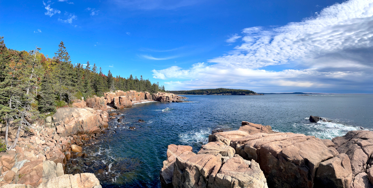
It All Starts Here: Gorham Mountain


Gorham Mountain Trail Starts just off the Park Loop Road past Thunder Hole. A small parking lot is available.
Every year my 1st hike is Gorham Mountain. Gorham Mountain is only 525 feet tall, so it is a quick hike, but it affords some great views of Frenchman’s Bay for not too much work. There is a split about 1/4 of the way up. Keep left for the pet friendly Gorham Mountain Path or right for the slightly more challenging Cadillac Cliffs.
I set my “beginning of the season time for hiking” on Gorham Mountain. I check again after 6 months of hiking to see my improvement. If my time at the end of the season is slower it may be a good time to visit the doctor.

Under 20 minutes up! You are probably not as old as me so plan on 30-45 minutes.
Bubble Bubble Nubble Bubble Bubble
I officially named this hike Bubble Bubble Nubble Bubble Bubble in 2022. It is a nice hike that starts with a bunch of casual day hikers …. and then gets peaceful and quiet. Plus it has a catchy name.

The hike starts at the Bubble Rock Parking Lot and ends there since that is probably where your vehicle is parked. It is about 5 miles total hiking. You start on the Bubbles Divide Trail following it to the Bubbles Trail and to Bubble Rock. Try and push the giant erratic (rock) off the edge like everyone else. Make sure you actually find the South Bubble peak marker, most people don’t cause they just want to see the damn big rock. Head back down the trail a bit and then up to North Bubble. Pay Attention to the trail markers, or better yet get a map. Lot’s of turns and everything is called Bubble something. I won’t be there directing traffic.

Bubble Rock on South Bubble Mountain. It’s bigger than it looks, you have to climb up there to see for yourself. Pemetic Mountain in the background.

You lose about 50% of the people if you go to North Bubble. Those are the ones that just want the photo op pushing the big rock on South Bubble. I think North Bubble has better views overlooking Jordan Pond. Regardless, it has less people! Stay a while or throw yourself off the mountain, whatever you like, then move on to Corner’s Nubble.

“Acadia Trails are generally most difficult (steep) on the West face of the mountains and least steep (but longer) on the South face due to the way the mountains were formed.”
The Grumpy Retiree
The hike from North Bubble affords panoramic views of Eagle Lake and Cadillac Mountain. After roughly a mile of gentle sloped hiking you cross the Eagle Lake Carriage Road to ascend Corner’s Nubble. There are a couple of rock scrambles, not too hard and you are at the top! Reverse the trail and don’t forget to go back up both North and South Bubble otherwise it is just Bubble Bubble Nubble trail and that does not have a good ring to the name.

Grumpy Tip: There are many variations of this hike. You can make it longer and/or a more challenging hike with a few variations. Park at Jordan Pond parking lot (good luck getting a spot at noon) and hike to the South Bubble via the Jordan Pond Path to the Bubbles Trail. This trail is steep and has a few difficult sections. If you don’t care about hitting South Bubble on the way back, go down the loose stone slope of the Bubble Divide Trail on the way back to Jordan Pond and the parking lot. This is 6-7 miles hiking and most people need 4+ hours to complete. An easier but long variation is to descend Conner’s Nubble to Eagle Lake Trail to Jordan Pond Carry Trail to the Bubble’s Parking Lot. Confused yet? You probably started the day that way, so don’t blame me.
When Should I go to Acadia National Park
I haven’t a clue what you like to see or do and care even less. Figure it out for yourself. Do some damn research, why rely on me. Pretty simple, go whenever the hell you want. Better yet, go when I am not around.

Lupine blooms in early June.
“Pretty simple, go whenever the hell you want. Better yet, go when I am not around.”
The Grumpy Retiree
Grumpy Tip: Most people visit from June through mid-October. May through mid June can be cool 50-60 degree days but I have seen days into the low 80’s in May. That help? Didn’t think so. Hiking is great in May & June and so are mosquitos and black flies if you like them. September & October are also great for hiking and the autumn colors arrive in October. Don’t ask me how to dress either damn it, do I look like your mother?
My favorite time at Acadia National Park? When there are relatively less people, but that is winter! I think last 2 weeks in June are great. If you want fewer rodents (kids), like I do, go mid-September through mid-October. In general anytime school is in session you have the Newly Wed or Nearly Dead visiting Acadia and the surrounding area. Things start shutting down the last week of October so you may have issues getting your stupid sea bug roll. (Lobster roll for the culinary disabled.)
Acadia and St. Sauveur Mountain Hike(s)


If you are into taking selfies, do everyone a favor and stay on Beehive Trail or better yet go to Cancun. Someplace far enough away so I can’t see or smell you. For the rest of you that want some moderate to slightly more difficult hiking read on.
Acadia Mountain and St. Sauveur Mountain are my next hikes and are on the quiet side of Mt. Desert Island in Southwest Harbor. The mountains are next to each other and provide some nice views of Somes Sound from their peaks. You can hike them individually (Acadia Loop 2.5 miles Sauveur Loop 3+ miles) or combine them for a longer 4-5 mile hike.

There are 2 parking areas off Rt. 102. The larger Acadia Mountain Parking and further south is parking for St. Sauveur Mountain. You can do either or both mountains from either parking area. Hell, you can get to Yosemite National Park from either parking lot for that matter if you want a really long hike.
Grumpy Tip: The trail section towards Somes Sound off Acadia Mountain peak has 2 less dog friendly areas as there are some steep drops. It can be done, especially with a smaller dog that can be handed down to someone. St. Sauveur Mountain’s return via Somes Sound towards the fire road is a little more pet friendly. There are a couple drops, but with care it can be done. Dogs on a leash (the rule in Acadia) can pull you over if you are not prepared. Consider everyone’s abilities and don’t be an idiot.
From the road to the mountain peaks is fairly easy hiking. Each mountain on their own can be done up and back for a short hike of about 1 hour for Acadia Mountain and about 1.5 hours for St. Sauveur. The trails facing Somes Sound have some steep difficult sections, especially if you are not experienced. So doing a loop is a little more difficult for some.


You can do a loop on either mountain by using the fire road that splits the two mountains apart. Also, Man O’ War Brook empties into Somes Sound near the fire road terminus. It is worth checking this out if you got that damn close. Those that are lazy can just walk down the fire road to Somes Sound and eliminate all that pesky climbing up and down. That is called a walk not a hike for the uninformed.
Grumpy Tip: The Valley Cove Trail section at the end of the Fire Road can be closed for Peregrine Falcon Nesting much of the season. This trail follows along Somes Sound at a lower elevation and leads to Flying Mountain. It is a great trail, but is not needed to hike either Acadia or St. Sauveur Mountain peaks. Precipice Trail headed up to Champlain Mountain also is closed for Peregrine Falcons frequently. Check the trail closures here.
There is a loop to Valley Peak off St. Sauveur, as shown on the map, if you want to extend the hike even further. The views of Somes Sound are about the same from either mountain peak. I think they are sightly better from St. Sauveur, but are slightly quicker to get to via Acadia Mountain. Acadia Mountain Trail from the trailhead is well marked and has several granite steps through the forest. St. Sauveur, also well marked, climbs over more rough sloped rock to start and then gradually through a wooded path.
On St. Sauveur the views are just past the peak marker. Follow the trail and use your damn map until you see the views or wing it and walk off the mountain for added excitement. There was a small fire on St. Sauveur (April 2023) and you can examine the regrowth along the way to the top.
Pemetic Mountain (4th Tallest at 1248 feet)
Pemetic is a mountain that is well worth a climb, but gets little attention. Everyone is thinking about the damn Bubble Rock or Jordan Pond and never notices poor Pemetic on the opposite side of the Park Loop Road. Pemetic is the 4th tallest mountain in Acadia National Park at 1248 feet. It offers great views of the North & South Bubbles, Eagle Lake, Jordan Pond and out to the Atlantic. You can make this a 2 hour hike or a 4-5 hour hike by adding some other peaks such as The Bubbles. I consider this a moderate trail.
Grumpy Disclaimer: I hike a lot in Acadia National Park. My Moderate Trail may be your Difficult or Easy trail. How in hell’s name do I know your skill level or degree of stupidity? You could fall and break a leg getting out of your car, and nobody calls that difficult. Stupid maybe, but not difficult. Use some common sense damn it! If reading this exhausts you, consider the hike exceedingly difficult.
There are basically 4 ways up to the top of Pemetic.
- Pemetic South Ridge Trail
- Pemetic East Cliff Trail
- Pemetic North Ridge Trail
- Pemetic NW (Ravine) Trail
I hiked Pemetic at least 6 times now and have done every trail. Do I have a favorite way up. No. There you go, work with that. This year I ran up the South Ridge Trail alone and hiked up the East Cliff Trail with my wife and people I know. Not friends mind you as nobody likes me enough to be friends. There are people I know and people I don’t know, that’s it.

The East Cliff Trail has some more difficult rock climbing, but nothing too difficult, especially for experienced hikers. All the other trails to Pemetic are moderate, each having some small challenges here and there. The NW (Ravine) Trail splits between the Ledge & Ravine. The Ledge has steep bald ledge (walkable) and the Ravine goes into a ravine (ladders). That’s why they are called Ledge & Ravine. It’s amazing how much explaining I have to do.


Any of the trails can be done as an up and back by simply turning around and going back. There are endless loops that can be made. For example you can go up Pemetic via the the South Ridge Trail from Jordan Pond Parking, work your way to The Thirsty Whale in Bar Harbor and get a fish sandwich, then walk back to your car. Lot of variations nobody ever thought about.
A nicer, simpler and shorter loop would be to park at Jordan Pond Parking and follow the Jordan Pond Path counterclockwise around the pond. Take your picture below, unless I am coming cause I won’t wait for you to pose on the stones. Then hike up via the Canon Brook Trail/South Ridge Trail or slightly more challenging East Cliff Trail. Come down the Pemetic NW (Ravine) trail. Then cross the Park Loop road to the Bubbles Parking lot and back to Jordan Pond via the Jordan Pond Carry Trail.

From Jordan Pond parking. Cross the stepping stone bridge and take this picture, everyone else does, and then look for the trail sign to Pemetic just ahead.
Beech Mountain (839′ & 15th tallest in Acadia)
Beech Mountain is a favorite of many hikers as it is relatively easy, offers good views to Southwest Harbor and the open ocean, is the only peak in Acadia with a Fire Tower and is also pet friendly. Popular and parking however don’t quite sync up as parking is a premium at the Beech Mountain Trailhead.
Listed below are a few trails up Beech Mountain many of which can be combined in some fashion to make a loop. The most popular Beech Mountain hike is to park in the lot at the end of Beech Hill Road. The trail proceeds conveniently near the heavenly scented outhouse facility. Take your 1st left shortly after entering the trail and you will have a moderate half mile ascent to the fire tower. Climb the iron rung fire tower stairs, take a picture of the sweeping views or have some lunch below the tower. Feel free to Ohhh & Ahhh as long as I am not there.
Don’t return the same damn way! Head down opposite the fire tower towards Beech Mountain West Ridge Trail but take a right to stay on the Beech Mountain Loop loop at the first turn a short distance down. You get great views overlooking Long Pond and Mansell Mountain. Hiking down this way is gradual and the complete loop is just over a mile. Depending how many Ohhhing and Ahhhing’s you do, expect to take about 1 hour for the loop. Food not included.

Ways to hike Beech Mountain
- Beech Mountain Trail from Beech Mountain Trailhead parking at the end of Beech Hill Road
- Beech South Ridge & West Ridge from Long Pond
- Canada Cliffs or Beech Cliffs Trails from Echo Lake
My Beech Mountain Hike

My return along Long Pond was equaling rewarding in the variety of views. If one cannot come to Acadia and see all the subtle changes, the glow of summer sun through the forest of mist and trees, the tiny pink and white bells of blueberries blossoming at our feet and the call of the hermit thrush, that is a loss on their part. Is not just sun swept vistas of the open ocean and rock that makes Acadia a special place. Lingering in one spot watching the changes, listening for the red squirrel, and laugh with it as it chirps loudly explaining that you are the intruder. Fog and mist have a natural way to slow you down to enjoy what one never notices when the sun shines and illuminates the blue sky melding with the lakes or ocean.


I returned to my vehicle happy to get a small hike in, but I needed one more peak in my quest to complete the 26 Acadia Peaks.
Bernard Mountain (1071′ & 6th tallest in Acadia)
I have a love hate relationship with Bernard Mountain. It always seems far removed from most of the other peaks in Acadia National Park and invariably is one of the last peaks I climb in my quest for all 26 Acadia National Park peaks. This year I set to enjoy Bernard Mountain, as best I can. Bernard is the least Instragram worthy hike, in other words far fewer tourist hikers on the trails.
As always there are a few ways to scale a mountain in Acadia and Bernard is no exception. Below are some of the trails that connect to Bernard Mountain. Up and Down or Loops can be done by combining trails. Look at a map! Most hikes are in the 3-5 mile range and in some cases they have some moderate to difficult sections, nothing an experienced hiker cannot handle.
- West Ledge Trail from Seal Cove Pond Road
- Bernard Mountain Trail from Mill Field
- Sluiceway Trail from Mill Field
- Gilley Trail from Gilley Field
- Perpendicular/Razorback/Bernard Mt. Trail from Long Pond
- Great Notch Trail from Long Pond Fire road

I am not going to explain every trail as ITC (It’s Too Complicated). Remember this is my hiking journal, not a damn reference book. I prefer to hike the moderate West Ledge Trail at 3.2 miles round trip. Or if I have the time and energy start at Long Pond and hike up Mansell Mountain via the Perpendicular Trail. You can then start down Razorback, connecting to Bernard Mountain Trail down through Mill Field and Gilley Field to Long Pond. Or just wing it, get lost and have a story to tell.
My Bernard Mountain Hike
After Beech Mountain I drove the remote dirt roads of Acadia to get to the 3 parking spots for West Ledge Trail on Seal Cove Pond Road. I find only 1 other vehicle parked, therefore the trail should be tranquil.
Again, I find myself in the fog as it seems to follow me up the mountain trail. There are a few steep bald faced sections still wet from all the rain. Traction here and there is slippery, but not dangerous as I took my time so not to fall and again see my wife’s exasperated glance at my scraped knees on my return home. Bumbles bounce I tell her.


The West Ledge Trail rises quickly at the beginning but as you approach the top the hike flattens. There are several groves of tall spruce seeming planted in a business like manner. The forest floor is carpeted in moss and brown spruce needles. The hiking under foot here is soft compared to the Maine granite. Near the top of Bernard the petrified snakes become more abundant. Additionally, Petrified snakes abound in Acadia and are slippery slimy creatures in this damp weather. But they keep the rodent population down in most cases, so are tolerated by grumpy retiree’s such as myself.
Reaching the summit of Bernard is only exciting in the fact that the hike was pleasant. There are no sweeping views, no open vistas, just the quiet satisfaction of the hike. I turn around almost immediately for the return trip back to my waiting vehicle.
Flying Mountain (284 feet 26th tallest in Acadia, in other words smallest)
Flying Mountain in Southwest Harbor is the smallest of the 26 peaks in Acadia National Park at 284 feet. From the parking lot or road it is an easy hike as a loop to the peak and back. You can hike counter clockwise up to Flying Mountain peak 1st and return via the fire road, my preferred method. Or go clockwise starting with the fire road at the far end of the lot. The complete loop is about 1.5 miles and usually takes about 1 hour with a stop at Valley Cove.

This is a nice quick hike, but because it is small and easy it is infested with rodents and their parents or old people, like me. You do get great views of Somes Sound for very little work and for many people very little work is still too much. The waterfront area on Somes Sound at Valley Cove is very nice and you can get into the water or toss in a less desirable member of your family. A lot of people bring food and have a picnic. Despite the don’t feed the animals policy, if you hover over a family long enough they give you a cookie or sandwich just to get you to go away.
Grumpy Note: Some really lazy people go down the fire road to Valley Cove, have a picnic and return via the fire road. You won’t even burn off 1/4 Twinkie’s worth of calories that way, and again, this is called a walk, not a hike.

My Flying Mountain Hike
I’ve hiked Flying Mountain many times over the years, all counter-clockwise. Starting from the parking lot I have a short hike through the trees, up some wooded steps and over a small rock scramble. All very easy. In under a quick 15 minutes I am at the top. The views afforded from Acadia’s smallest peak encompass Northeast Harbor, Somes Sound and out towards the Cranberry Islands. I always seem to takes some pictures here, which never do justice to the view, but once again I snapped a few photographs.


Flying Mountain is never an up and back hike for me. I always continue to picturesque Valley Cove on the edge of Somes Sound. Following the trail, I work my way to the Somes Sound overlook, while nice the overlook view never beats the Valley Cove beach further ahead. Again, I stop to see what is happening at the cove. Today a lobster boat makes it’s rounds in the sound.

Soon after I head off to the fire road towards my vehicle. A quick early morning hike with some nice views, what more can I ask for to start the day!
The Six Summits: Bald, Parkman, Gilmore, Sargent, Penobscot, Cedar Swamp


The Six Summits at Acadia National Park consist of the mountains Sargent, Penobscot, Cedar Swamp, Gilmore, Parkman and Bald. I was unaware that this was “A Thing” until after I did them in 2022 for the first time. One day I started hiking, and one mountain tends to lead to another and I had to get back to my car somehow. I didn’t mean to do “A Thing”, it just happened. Lately I find myself say “is that a thing” way more often than ever before. Toast Tongs, yup that’s a thing.
As always, there are many ways to hike a loop or “A Thing” in Acadia National Park. The way I do this loop is to start at the Norumbega Parking Lot, which is ironic as Norumbega Mountain is not part of the Thing. Cross Route 198, and the most challenging part of the hike is over. Start down the trail and and go past the Parkman Mountain trail sign. A bit further in over the petrified snakes will be the sign for Bald Mountain. I like to go up Bald Mountain first and since that’s the way I like to go it obviously is the best way.
Get a map, hire a Sherpa, follow someone or better yet follow some common sense. Figure out your route yourself. These are just general directions and I expect you got lost just after you crossed 198 anyway.
Head up Bald, aptly named for the open bald faced slope, and stop at the peak. You have some nice views along the way to Upper Hadlock Pond. Parkman is just 0.2 miles away and a quick easy hike. Within no time you have 2 Summits! Things get a little harder now as you need to go to Gilmore Mountain. From Parkman head down the Grandgent Trail. It is steep down into a gully. I like this part of the hike and always admire the diverse shades of green here. Admire all you want unless you see me coming then get out of the way. And be quiet damn it, especially here.

Keep going straight ahead up to Gilmore towards Sargent. Lots of petrified snakes and it is steep going up. Gilmore is a neglected mountain and probably suffers some inferiority complex, so give it some love and stop for at least 2-3 minutes. Next is Sargent Mountain, the 2nd tallest in Acadia at 1373 feet. Not bad for a an hour and a half hiking, or 3 depending on your speed. Not my problem.
Half way to A Thing, The 6 Summits
From Sargent to Penobscot starts pretty damn easy. You walk along some relatively level terrain until you get for the turn to Penobscot and Sargent Pond. Take a left and tumble down into the pond at the bottom. This is a unique feature at Acadia National Park and I always stop at least 30-45 seconds. No time to waste, keep moving until you come to a 4 way intersection where you go straight through, or don’t and get lost. From there it is only 1-2 tenths of a mile to Penobscot peak over a rock scramble and some open bald rock. I never stay long enough to notice, but you may get some views towards Cadillac mountain and Jordan Pond. Let me know.

You have 5 summits and Cedar Swamp is last on the list. If you are tired, you could head down now, but it isn’t much shorter than if you go to Cedar Swamp, so you kind of screwed. Stop whining and get going! Retrace your steps past Sargent Pond and when you get to the main trail take a left. It gets a bit confusing here, but at Birch Spring you head across up to Cedar Swamp. Remember the map I spoke about? Work with me.
(For those that know … you know where to go.)
Retrace back to Birch Spring. If you are expecting some magnificent spring here you will be sorely disappointed. It is pretty much a sign post. Take a hard left past the spring onto a small section of the Amphitheater Trail towards Hadlock Brook Trail. When you get to Hadlock Brook Trail turn left again all the way back to your vehicle, rickshaw or what not. Along the way on this section is Hadlock Falls. Even the Grumpy Retiree likes Hadlock Falls. So stop and linger a full minute if you want.

A quick 3-6 hours and 7.5 miles and the morning is over and now if you were good you can get some lunch. There you go, the Six Summits, you did “A Thing”!
My 6 Summits Hike(s)
I first did this hike in 2022 by accident, just started hiking and said “that peak isn’t too far” until I did all 6 peaks. In 2023 I decided to make this “an annual thing”. So far I have done this 2 times in 2023. The first time I was completely exhausted heading up to Gilmore and then Sargent. I went via parts of the Giant Slide Trail and Maple Spring Trail. This is the long way and took 4.5 hours and 9 miles hiking. The second time I had conditioned myself hiking in the 2023 season and it was a lot easier. It took 3 hours for the 7.5 mile hike detailed previously and that was in the rain on the last 3 peaks!


My favorite part of this hike is the Grandgent Trail off Parkman. The trail falls steeply down for a short period, but what awaits you at the bottom is a special spot in Acadia. Seldom traveled, the area seems forgotten in time, as it has been for hundreds of years. The absolute quiet here, the moss covered rocks, it is a wonderful pause before the steep uphill over petrified snakes awaiting you just ahead.
Like any hike in Acadia National Park, there always are a incredible variety of sights, sounds and terrain, especially when traversing 6 different summits. The croak of a frog and the play of a dragonfly over the mirrored water on Sargent Pond. Or Hadlock Falls and the Carriage Road bridge. All great stops, even if only for a moment for me.
Cadillac Mountain (1530 feet tallest in Acadia), Dorr Mountain (1270 feet 3rd tallest) & Kebo Mountain (407 feet 2nd smallest)
Cadillac is the tallest mountain in Acadia National Park. It is the only mountain that has a road to the summit, for better or worse, for lazy tourists. Also, everybody and their mother now needs to drive up Cadillac to see the Sunrise or the Sunset. As if that is the only spot on the Maine coast that either phenomenon occurs. Well … there is something special about the sunrise on Cadillac. Cadillac Mountain is the 1st place on mainland US to see the sunrise certain times of the year.
Interesting Facts: Cadillac Mountain’s original name was Green Mountain. Real inventive naming back in the day. There have been damn tourists going up Cadillac Mountain forever it seems. Over the years several hotels existed on top and even a cog railroad traveled to the top. Read more interesting facts here.

View over Frenchman’s Bay from top of Cadillac Mountain
The damn mountain has become so darn busy with tourists than you need a timed reservation to drive to the top between May and October. And those Sunrise and Sunset reservations are difficult to come by as this has become a “thing” to do on Mount Desert Island.
You can avoid the reservation system altogether by hiking to the top. Of course hiking to see Sunrise or Sunset means some part of your hike will be in the dark. That doesn’t seem to stop some folk, do what you want. As long as the sun rises, I don’t need to be the first to see it any longer. Worse, if you show up, and the sun doesn’t rise that day we have a problem, and you are first to have to deal with it.
Disclaimer: OK, I have to admit my wife and I climbed up Cadillac Mountain in the winter no less to see the sunrise. December 31, 1999 to be exact to see the sun show up for the year 2000. It didn’t. It was foggy and cold and while I didn’t SEE the Sunrise, the sun did rise … so I’m told. But we were there! And my wife will never let me forget that.
There are several ways as expected to hike your ass up Cadillac. Most popular are the North and South trails up the mountain. The South Ridge is longer (3.5 miles one way) but most gradual while the North Ridge is 2 miles from the Park Loop Road but still not too strenuous.
View from North Ridge Cadillac trail


North Ridge Cadillac trail
North Ridge Cadillac

Coming up from the East you either have to take the Gorge Trail and scramble up some steeper sections between Dorr Mountain and Cadillac, or hike up and over Dorr Mountain, down into the gorge, and then up Cadillac Mountain. The West Face is considered the most difficult. Leave it at that. There are other connecting trails in the vicinity so you can extend your hike. Remember the map?
My Cadillac, Dorr & Kebo Mountain Hike
I have hiked Cadillac via all the trails mentioned above. I like the West Face the best as it offers more of a challenge. However, this time my hike was up the Gorge Path, which in a word was … delightful. The Gorge Path starts by a bridge off the Park Loop Road and then into a wonderful forest walk. The trail proceeds to follow the gorge and crisscrosses Kebo Brook for much of the 1st half. This trail can be wet, especially after rain, and if you are careless there are a few spots you may get your feet wet. Today it is a real joy to see the water cascading down the gorge and the shear cliffs of Dorr Mountain, right up to the last brook crossing where I put my foot into the water. Damn it!


With one very wet foot, I eventually arrive at the crossroad between Dorr and Cadillac Mountain. You can turn left up Dorr Mountain, or turn right up Cadillac at this crossroad. This being a Cadillac Mountain hike, expand your mind and figure out which way I went.

The climb up to Cadillac from the gorge is under 1/2 mile, but the going is steep over some large granite boulders. Just to add some excitement to the steep rock, it begins to rain. At least I am completely wet, nobody knows I accidentally stepped into a brook. That’s better.
I know when I am closing in to the top as I meet idiot tourists that drove up Cadillac start heading down this trail. Usually they come to their senses at some point and get in your way as they return to the family chariot parked at the summit.
My work is not complete when I get to the summit. The first very important thing to remember if you hike up Cadillac Mountain is not to look anyone that didn’t hike up in the eye. You will know the hikers verses the drivers. Hikers covered in sweat, drivers not so much. I always feel a sense of accomplishment when I hike to the Cadillac Summit. A bit smug even. Bask in your glory for a while before you complete your final task. PS. I’ve driven up Cadillac Mountain many times, but I wear a disguise.
The summit marker for Cadillac Mountain is not near the parking area. I suspect the majority of the people never find the marker, but my hike up Cadillac Mountain is not complete until I see the actual peak marker. I make my way to the gift shop and walk down the path to the left towards the start of the West Face Cadillac Trail. Within a few hundred feet of the shop to the right there is a small lonely mound signifying the top of Cadillac Mountain. Only now can I say I hiked Cadillac Mountain.

My return this day was to retrace my steps down the east side of Cadillac Mountain to the Gorge Path. Still having some energy, I decide to climb up the gorge to Dorr Mountain. The climb up to Dorr is almost a reflection of the climb up to Cadillac, sans tourists. Poor Dorr Mountain sits in Cadillac’s shadow, and without a road, is always free of crowds. I stay my requisite 1-2 minutes on Dorr peering at the hoards of people on top of Cadillac Mountain. Most oblivious of Dorr or my accompanying presence.
Note: There are many other hiking trails, in particular up Dorr Mountain. Homans Path, Emery Path, Kurt Diederich’s Climb, Schiff Path and Ladder Trail to name a few. You can combine trails and mountain peaks all day long.
The final leg of this hike descends the slippery North Ridge of Dorr Mountain. The rain made the granite here surprising slick this on this otherwise easy hike. I encounter a few small slips along the way, nothing too serious, but the going is slower than normal. Last I hike up and over little Kebo Mountain before I intersect the Park Loop Road.


The forest trees of Kebo Mountain always seem a little different than other places in Acadia National Park. A little more forbidding like the scary trees in the Enchanted Forrest of The Wizard Of Oz. None tossed any apples my way and I made it to the Park Loop Road and returned safely to my vehicle. Total hike about 6 miles and 3.5 hours. No flying monkeys.
Next hike: TBD

Remember, to complete your subscription to the blog you MUST go to your email and Accept! Check your Spam/Junk folder for the email if you don’t see it!


0 Comments